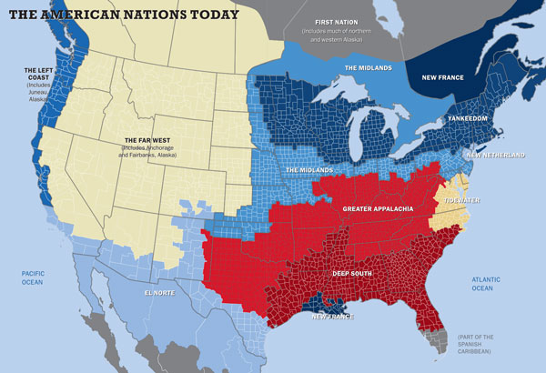
The borders of my eleven American nations are reflected in many different types of maps—including maps showing the distribution of linguistic dialects, the spread of cultural artifacts, the prevalence of different religious denominations, and the county-by-county breakdown of voting in virtually every hotly contested presidential race in our history. Our continent’s famed mobility has been reinforcing, not dissolving, regional differences, as people increasingly sort themselves into like-minded communities, a phenomenon analyzed by Bill Bishop and Robert Cushing in The Big Sort (2008). Even waves of immigrants did not fundamentally alter these nations, because the children and grandchildren of immigrants assimilated into whichever culture surrounded them.
Before I describe the nations, I should underscore that my observations refer to the dominant culture, not the individual inhabitants, of each region. In every town, city, and state you’ll likely find a full range of political opinions and social preferences. Even in the reddest of red counties and bluest of blue ones, twenty to forty percent of voters cast ballots for the “wrong” team. It isn’t that residents of one or another nation all think the same, but rather that they are all embedded within a cultural framework of deep-seated preferences and attitudes—each of which a person may like or hate, but has to deal with nonetheless.

via Tufts Magazine / fall 2013.


Leave a comment